Turn on suggestions
Auto-suggest helps you quickly narrow down your search results by suggesting possible matches as you type.
Showing results for
- Good Sam Community
- Everything RV
- Campground 101
- Re: Vermilion Cliffs
Options
- Subscribe to RSS Feed
- Mark Topic as New
- Mark Topic as Read
- Float this Topic for Current User
- Bookmark
- Subscribe
- Mute
- Printer Friendly Page
Vermilion Cliffs
Options
- Mark as New
- Bookmark
- Subscribe
- Mute
- Subscribe to RSS Feed
- Permalink
- Report Inappropriate Content
Jan-12-2019 10:50 AM
Not exactly sure which forum would be best for my post, but I have to drive a new Dodge Diesel 4x4 truck from Ct. to AZ and as long as I have to make the trip I wanted to see some places I never saw before in the MH. In particular I wanted to see some places in the Vermilion Cliffs area such as Antelope canyon, marble canyon, paria canyon and anything else in that area that others have found interesting. In looking at the web sites it looks like permits are need to enter these places, and if I understood them correctly from Nov to mid March you can apply as a walk in and hike the same day. Has anyone done this? Also during this time is snow a problem, we would be staying at hotels at night.
Labels:
- Labels:
-
Boondocking
-
Dry Camping
-
Public Lands
28 REPLIES 28
Options
- Mark as New
- Bookmark
- Subscribe
- Mute
- Subscribe to RSS Feed
- Permalink
- Report Inappropriate Content
Jan-23-2019 04:12 AM
Yes, the weather will determine where you can (should) go. But there's plenty to do and see, so I have no doubt that you'll have an awesome time. Just have some flexibility in your planning.
Options
- Mark as New
- Bookmark
- Subscribe
- Mute
- Subscribe to RSS Feed
- Permalink
- Report Inappropriate Content
Jan-22-2019 06:22 PM
SteveAE wrote:I guess a lot depends on the weather, we my just have to be satisfied with antelope canyon and some non permit hikes, I would hate to get stuck in mud 20 miles in on a dirt road with someone else's new truck.
I don't know if this will help but here goes:
Unless you do the much longer loop (think backpacking), the Paria is (or used to be) a self issue permit at the trail head. It's just a walk down the river. You will be in the water (possibly up to your waist in places). It will be cold and the mud will stick to everything (and the stain will take months to clean out). Don't misunderstand, it's a wonderful place, just go prepared...bring trekking poles and clothes you don't mind either laundering multiple times or just throwing away.
As you are aware, The Wave requires a permit...which can be hard to get. You used to be able to get this permit from the Paria Contact Station, not too far from the dirt road that goes down to the Wave trail head. Now (well, once the shutdown ends), you have to go to Kanab for the permit. Kanab is about 40 miles west of the dirt road that leads to the Wave trail head. There is an alternative however...... If you go to the Paria Contact Station, they will call the Paria office and, IF there are any open permits, they will issue it to you from there. Saves 80 miles of driving..... For best "luck" getting a permit however, I suggest you just go to the Kanab BLM office. Good luck.
But don't dispair. South Coyote Buttes is also very pretty. It now requires a permit (same office), but the likelihood of getting it is much greater than the Wave (everyone wants the Wave...silly folks....).
Keep in mind that, in February, it can be cold down there and there might be some snow (personally, I wouldn't want to wander down the Paria canyon then). Snow isn't a problem, but those roads can turn into a real mess when wet. DO NOT venture down them when there is a lot of rain coming.....unless you want to wait for a day or three until it all drys out.
Some awesome options in that area are:
- South Coyote Buttes
- wander up Cottonwood Canyon Rd. (north) into the Coxcomb (part of Escalante National Monument)
- Paria Movie Set (a cool area north of hwy 89...The Wave is South of 89)
- Just east of Page is the "New Wave". I have not been there, but it might be worth checking out????
- The visitor center in Big Water (assuming the gov. shutdown is over) is well worth a stop and they can make suggestions on where to explore.
- You are aware of Antalope Cyn., but IF you have a boat, Antelope Canyon can also be accessed from Lake Powell. Not the same, but it's free.......
There is just so much to do down there. Headed back to that area (again) for a couple months in March ourselves.
If you are into getting books, check out this one.
I doubt that you will be disappointed.
Oh yea, this is an El Nino year so they are getting lots of moisture down there (at the present). Might be something you want to factor in (watch out for those dirt roads in the rain!)
Hope this helps and ......... have fun.
Options
- Mark as New
- Bookmark
- Subscribe
- Mute
- Subscribe to RSS Feed
- Permalink
- Report Inappropriate Content
Jan-21-2019 04:18 PM
I don't know if this will help but here goes:
Unless you do the much longer loop (think backpacking), the Paria is (or used to be) a self issue permit at the trail head. It's just a walk down the river. You will be in the water (possibly up to your waist in places). It will be cold and the mud will stick to everything (and the stain will take months to clean out). Don't misunderstand, it's a wonderful place, just go prepared...bring trekking poles and clothes you don't mind either laundering multiple times or just throwing away.
As you are aware, The Wave requires a permit...which can be hard to get. You used to be able to get this permit from the Paria Contact Station, not too far from the dirt road that goes down to the Wave trail head. Now (well, once the shutdown ends), you have to go to Kanab for the permit. Kanab is about 40 miles west of the dirt road that leads to the Wave trail head. There is an alternative however...... If you go to the Paria Contact Station, they will call the Paria office and, IF there are any open permits, they will issue it to you from there. Saves 80 miles of driving..... For best "luck" getting a permit however, I suggest you just go to the Kanab BLM office. Good luck.
But don't dispair. South Coyote Buttes is also very pretty. It now requires a permit (same office), but the likelihood of getting it is much greater than the Wave (everyone wants the Wave...silly folks....).
Keep in mind that, in February, it can be cold down there and there might be some snow (personally, I wouldn't want to wander down the Paria canyon then). Snow isn't a problem, but those roads can turn into a real mess when wet. DO NOT venture down them when there is a lot of rain coming.....unless you want to wait for a day or three until it all drys out.
Some awesome options in that area are:
- South Coyote Buttes
- wander up Cottonwood Canyon Rd. (north) into the Coxcomb (part of Escalante National Monument)
- Paria Movie Set (a cool area north of hwy 89...The Wave is South of 89)
- Just east of Page is the "New Wave". I have not been there, but it might be worth checking out????
- The visitor center in Big Water (assuming the gov. shutdown is over) is well worth a stop and they can make suggestions on where to explore.
- You are aware of Antalope Cyn., but IF you have a boat, Antelope Canyon can also be accessed from Lake Powell. Not the same, but it's free.......
There is just so much to do down there. Headed back to that area (again) for a couple months in March ourselves.
If you are into getting books, check out this one.
I doubt that you will be disappointed.
Oh yea, this is an El Nino year so they are getting lots of moisture down there (at the present). Might be something you want to factor in (watch out for those dirt roads in the rain!)
Hope this helps and ......... have fun.
Options
- Mark as New
- Bookmark
- Subscribe
- Mute
- Subscribe to RSS Feed
- Permalink
- Report Inappropriate Content
Jan-21-2019 10:09 AM
No for the wave you have to get a permit at the ranger station. However I don't believe that they run the lottery when there is low demand for permits. Check online. Paria for day trips is always at the trailhead.
Arctic Fox 25Y Travel Trailer
2018 RAM 2500 6.7L 4WD shortbed
Straightline dual cam hitch
400W Solar with Victron controller
Superbumper
2018 RAM 2500 6.7L 4WD shortbed
Straightline dual cam hitch
400W Solar with Victron controller
Superbumper
Options
- Mark as New
- Bookmark
- Subscribe
- Mute
- Subscribe to RSS Feed
- Permalink
- Report Inappropriate Content
Jan-21-2019 10:06 AM
The BLM web site says, "Permits are required for both day hiking and overnight trips in Paria Canyon and Buckskin Gulch. Walk-up permits are available for day hiking at the trailheads, but overnight permits must be obtained through the Paria Canyon online permit application system. Overnight permits can also be obtained in person the day of your hike, IF there are any permits available". So does that mean for day hikes to the first wave you don't need to go through the lottery system just go to the trail head and pay the $7 fee and you can hike in?
Options
- Mark as New
- Bookmark
- Subscribe
- Mute
- Subscribe to RSS Feed
- Permalink
- Report Inappropriate Content
Jan-21-2019 07:56 AM
Thanks for the trip report Frances, in reading some of the other web sites they say it is easy to miss the trail to the first wave. Hopefully we will be able to obtain a permit in February and it should be much cooler. I really enjoyed your photos Jon, I guess in the winter the sunlight would not filter down the canyon like you captured in your photos.
Options
- Mark as New
- Bookmark
- Subscribe
- Mute
- Subscribe to RSS Feed
- Permalink
- Report Inappropriate Content
Jan-20-2019 09:03 AM
Gjac wrote:I've done both the upper & lower - have a web page of photographs & information about both.
Thank you guys for all the information. Those of you that have made the antelope canyon tours which one is better the upper canyon tour or the lower canyon tour?
As to which - the upper is fairly flat walking on sand, but very crowded. I took a photo tour for both trips. More time in the canyon than the standard tour, and the guide will hold the crowd back so you can get an empty photo (within reason).
I don't know if they still do this, but when I toured the lower canyon, they gave you a tag & turned you loose (no guide) in the canyon for 2 hours. I only saw one other person during the entire 2 hours (I did arrive at 9:00AM, the first time slot). It is not a flat floor, with ladders in places. I preferred the lighting at the upper, but both are well worth it.
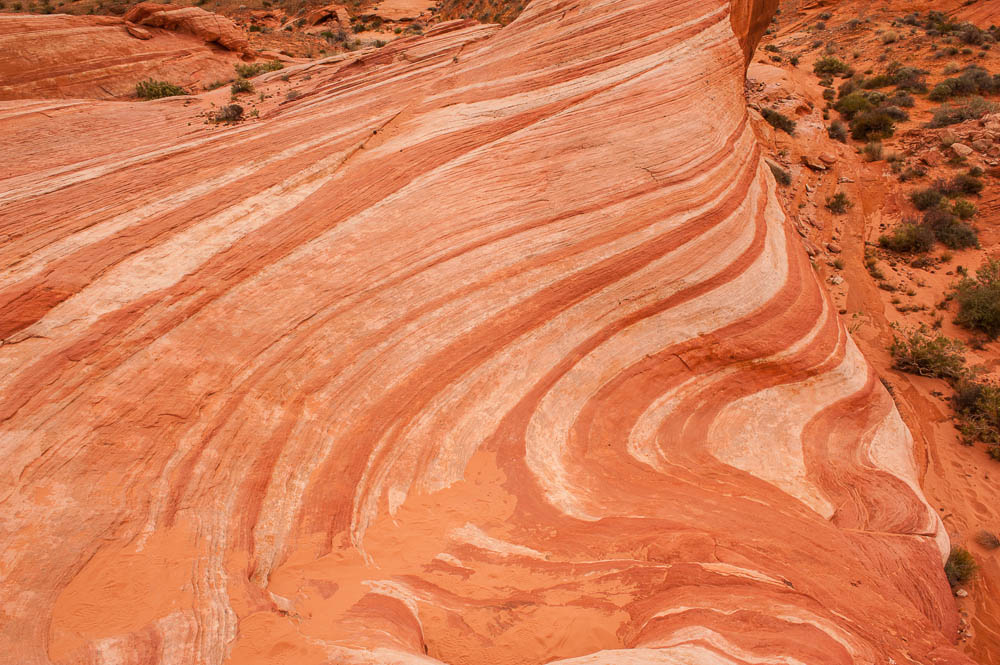
While no where near as impressive as the real Wave, there is a much easier to get to (and no need for permits) wave like formation at The Valley of Fire State Park in Nevada called the Fire Wave:
Options
- Mark as New
- Bookmark
- Subscribe
- Mute
- Subscribe to RSS Feed
- Permalink
- Report Inappropriate Content
Jan-20-2019 08:38 AM
Gjac, yes, only to the first. At the time we didn't know much about the second wave or how to get there or how long it would take.
I asked my husband if he could remember how long it took us to hike in. He wasn't sure but thought maybe 2 hours. However - we stop, a lot, to take photographs. We missed the turn-off to The Wave and continued down the wash on the Buckskin Gulch Trail for a good distance before we realized our mistake. Easily lost 30 minutes, maybe more, on having to backtrack. May 18 was hot. We hit the high 90s and so we stopped a lot to drink. This was also our first hike over slick rock and through areas with no real established trail. After the Ranger told us a lot of people never find The Wave, we spent probably more time than necessary checking the map, landmarks, compass, and GPS.
It took us less time to hike back out than it did to hike in. We were more confident of the trail, especially since we had our GPS cookie crumbs to follow. We'd also already photographed most of the "cool stuff" on the way in so didn't stop as much.
In all from start to finish at the trailhead, we were gone between 5 and 5 1/2 hours.
If you can't get a permit for The Wave. Or if you decide your knees might not co-operate, there is another hike we did on another trip. It's to a formation called the Nautilus. Compared to The Wave, it's tiny and not nearly as spectacular, but the hike isn't as long or hard. The formation is mostly white with a few scattered bands of golden oranges and yellows scattered through it. A Ranger told us about it and we considered it worth the effort. However, we are a bit nuts about rock formations and interesting geology so others might not agree.
Whatever you decide to do. Enjoy. It's so beautiful out there.
Frances & Tom with 3 rescue cats - Peaches, Snippet,and BP. And in spirit Aja (Dec 2014) and Tipper (Oct 2016).
2011 Winnebago Vista 30W
2008 4 door Hardtop Wrangler Unlimited 4X4
2011 Winnebago Vista 30W
2008 4 door Hardtop Wrangler Unlimited 4X4
Options
- Mark as New
- Bookmark
- Subscribe
- Mute
- Subscribe to RSS Feed
- Permalink
- Report Inappropriate Content
Jan-19-2019 06:32 AM
Floridafrances wrote:Hi Frances, so did you just hiked to the first wave? How long did it take you?
Gjac,
My husband and I hikes to The Wave in May, 2006 when we were both still young whippersnappers (61 and 57). Your winter temps would be better than the heat we had, but your daylight hours would be shorter.
As mentioned, this is mostly an unmarked trail. People don't always find it the first time, including the Ranger we talked to the day before our hike. We did get there, but you really do have to pay attention to the maps and landmarks info they give you. We had a handheld GPS with the various way points and co-ordinates we'd gotten from a number of sources. But you frequently can't go in a straight line from point to point. That's where the landmarks and directions come into play.
Even though we're from Florida, the hardest part for us was the sand dune shortly before you reach The Wave. It felt like we slid back two steps for every three we took up. Coming back down it was much easier.
It was well-worth the effort and we'd love to do it again if we ever have the chance.
Safe travels.
Options
- Mark as New
- Bookmark
- Subscribe
- Mute
- Subscribe to RSS Feed
- Permalink
- Report Inappropriate Content
Jan-18-2019 02:52 PM
Gjac,
My husband and I hikes to The Wave in May, 2006 when we were both still young whippersnappers (61 and 57). Your winter temps would be better than the heat we had, but your daylight hours would be shorter.
As mentioned, this is mostly an unmarked trail. People don't always find it the first time, including the Ranger we talked to the day before our hike. We did get there, but you really do have to pay attention to the maps and landmarks info they give you. We had a handheld GPS with the various way points and co-ordinates we'd gotten from a number of sources. But you frequently can't go in a straight line from point to point. That's where the landmarks and directions come into play.
Even though we're from Florida, the hardest part for us was the sand dune shortly before you reach The Wave. It felt like we slid back two steps for every three we took up. Coming back down it was much easier.
It was well-worth the effort and we'd love to do it again if we ever have the chance.
Safe travels.
Frances & Tom with 3 rescue cats - Peaches, Snippet,and BP. And in spirit Aja (Dec 2014) and Tipper (Oct 2016).
2011 Winnebago Vista 30W
2008 4 door Hardtop Wrangler Unlimited 4X4
2011 Winnebago Vista 30W
2008 4 door Hardtop Wrangler Unlimited 4X4
Options
- Mark as New
- Bookmark
- Subscribe
- Mute
- Subscribe to RSS Feed
- Permalink
- Report Inappropriate Content
Jan-16-2019 07:52 AM
agesilaus wrote:Elevation was a problem for me years ago in Colorado, I got high altitude sickness at 9,000 ft constant head ache, could not sleep, low energy once I got down to 6000 ft I was fine. In the last 10 years it did not seem to bother me as much.
No we've been to a number of other slot canyons up around Escalante UT but not those. I am generally adverse to paying for tours so we haven't been to Antelope either.
Let me mention something else as one flatlander to another, I'm not sure what altitude those canyons are but it's probably 6,000 ft or more. Unless you are acclimated to the altitude your energy level will be much lower than you expect. Especially when hiking up climbing trails.
Options
- Mark as New
- Bookmark
- Subscribe
- Mute
- Subscribe to RSS Feed
- Permalink
- Report Inappropriate Content
Jan-15-2019 01:27 PM
No we've been to a number of other slot canyons up around Escalante UT but not those. I am generally adverse to paying for tours so we haven't been to Antelope either.
Let me mention something else as one flatlander to another, I'm not sure what altitude those canyons are but it's probably 6,000 ft or more. Unless you are acclimated to the altitude your energy level will be much lower than you expect. Especially when hiking up climbing trails.
Let me mention something else as one flatlander to another, I'm not sure what altitude those canyons are but it's probably 6,000 ft or more. Unless you are acclimated to the altitude your energy level will be much lower than you expect. Especially when hiking up climbing trails.
Arctic Fox 25Y Travel Trailer
2018 RAM 2500 6.7L 4WD shortbed
Straightline dual cam hitch
400W Solar with Victron controller
Superbumper
2018 RAM 2500 6.7L 4WD shortbed
Straightline dual cam hitch
400W Solar with Victron controller
Superbumper
Options
- Mark as New
- Bookmark
- Subscribe
- Mute
- Subscribe to RSS Feed
- Permalink
- Report Inappropriate Content
Jan-15-2019 10:58 AM
agesilaus wrote:Yeah, I saw that one and decided against Paria Canyon for that reason plus it looked like it was more suited to overnight stays rather than day hikes. Have you hiked either the Wave or Paria Canyon?
maybe a partial hike to the first wave(see agesilaus video) if we can get a permit
--------------------------------
Just make sure you watch the Paria hike video, the last of the three I posted. It seems to be by the BLM and clearly describes the dangers. It covers the wave too.
Options
- Mark as New
- Bookmark
- Subscribe
- Mute
- Subscribe to RSS Feed
- Permalink
- Report Inappropriate Content
Jan-15-2019 09:40 AM
maybe a partial hike to the first wave(see agesilaus video) if we can get a permit
--------------------------------
Just make sure you watch the Paria hike video, the last of the three I posted. It seems to be by the BLM and clearly describes the dangers. It covers the wave too.
--------------------------------
Just make sure you watch the Paria hike video, the last of the three I posted. It seems to be by the BLM and clearly describes the dangers. It covers the wave too.
Arctic Fox 25Y Travel Trailer
2018 RAM 2500 6.7L 4WD shortbed
Straightline dual cam hitch
400W Solar with Victron controller
Superbumper
2018 RAM 2500 6.7L 4WD shortbed
Straightline dual cam hitch
400W Solar with Victron controller
Superbumper


