Turn on suggestions
Auto-suggest helps you quickly narrow down your search results by suggesting possible matches as you type.
Showing results for
- Good Sam Community
- Groups
- Fifth Wheel Group
- Forum
- Re: Off Road Riding Spots (with coordinates)
Options
- Subscribe to RSS Feed
- Mark Topic as New
- Mark Topic as Read
- Float this Topic for Current User
- Bookmark
- Subscribe
- Mute
- Printer Friendly Page
Off Road Riding Spots (with coordinates)
Options
- Mark as New
- Bookmark
- Subscribe
- Mute
- Subscribe to RSS Feed
- Permalink
- Report Inappropriate Content
Feb-10-2006 06:04 AM
Hey folks...
I won't even try to take credit for this, but I've had this info in my "favorites" for a long time.. I figured I'd share.. I make no claims to how accurate any of these are, but the dozen or so I've used were spot on..
Please feel free to add to it with your favorite spots. If you have coordinates to the spot, I'll add those to this list. This will make finding the spots with tools like Google Earth much easier. I will do my best to modify it and add riding spots as they are posted to this thread.
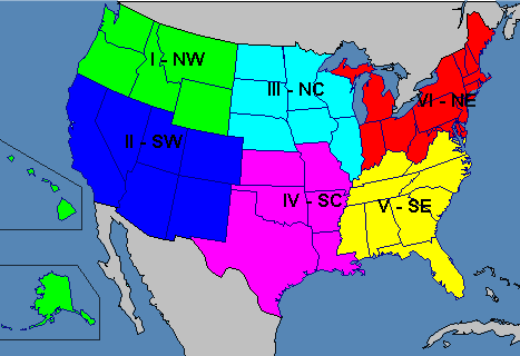
If everyone agrees, I will organize this by region. I could list them by state, but that didn’t seem right to me (read: too much work)…As of now, I will create to following regions: Southwest, Northwest, North Central, South Central, Southeast and Northeast. Our neighbors to the North and South will each get one region (I will add more as spots are posted.) Canada and Mexico
This map is a good reference for the regions..
Southwest
Lucerne Valley / Stoddard Valley / Johnson Valley and SW High Desert
Anderson Dry Lake Camp N34 33.635 W116 46.602
Bessimer Mine Camp (Rock Pile) N34 29.967 W116 39.852
Bessimer Mine Rd (Entrance from US 247) N34 24.587 W116 43.345
Cougar Buttes Camp N34 29.298 W116 49.454
Cougar Buttes Entrance from Camp Rock Rd. N34 29.950 W116 49.818
Cave/Mine (Between Bell Mtn. & Slash X N34 41.483 W117 07.100
Cave/Mine (Anderson Dry Lake) N34 34.064 W116 43.423
Cave/Mine (Anderson Dry Lake) N34 34.673 W116 40.772
Sand Dunes (East of Soggy Dry Lake) N34 25.434 W116 35.599
Bessimer Mine Rd. (Soggy Dry Lake) N34 28.072 W116 42.640
Wreckage (Lucerne Valley) N34 32.811 W116 40.303
Slash X Bar/Grille N34 45.605 W117 00.607
Sand Track (Cougar Buttes) N34 28.736 W116 49.098
Hodge Road N 34 44.345 W 117 08.065
Dale Evans Parkway N 34 39.120 W 117 13.521
Randsburg (the town itself) N 35 22.098 W 117 39.391
Searles Cutoff Staging (Red Mountain) N35 31.002 W117 39.545
Charlie’s Place (AKA Wagon Wheel,@ Red Mountain/Trona Rd.) N35 34.335 W117 32.939
Husky Monument N 35 13 12 W 117 19 00
El Mirage N 34 37.577 W 117 32.904
Dago N 35 08.347 W 117 51.462
Phelan Ridge Sand Hill 34°22'58.29"N 117°33'23.82"W
Hilltop Cafe staging area 34°23'24.57"N 117°34'30.82"W
Phelan Play Track 34°23'50.44"N 117°31'11.48"W
Rasor Rd.
Camp (Were we camp) N35° 5.579' W116° 7.693'
Trees N35° 5.423' W116° 7.71'
Sand Bowl (Half Pipe) N35° 4.660' W116° 9.318'
Gravesite N35° 2.742' W116° 9.891'
Desert Megaphone N35° 1.382' W116° 11.904'
Outside California City off of 20 Mule Team Rd
Campsite N35° 15.709' W117° 49.362'
Campsite N35° 15.207' W117° 49.457'
Campsite N35° 12.285' W117° 49.079'
Campsite N35° 11.332' W117° 52.278'
Campsite (By a Huge Water Container) N35° 14.975' W117° 46.777'
Copper City Rd. - Near Barstow
Camp (Were we camp) N35° 4.277' W116° 59.265'
Spider (Halloween Decoration) N35° 9.607' W117° 4.953'
Superior Dry Lake Bed N35° 14.937' W117° 1.152'
Fossil Canyon N35° 2.757' W117° 6.919'
Owl Canyon N35° 1.213' W117° 0.963'
Rainbow Basin N35° 2.088' W117° 2.206'
So Cal Mountain areas
Cajon Pass Staging area (by RR tracks) 34°19'57.57"N 117°28'44.51"W
Cleghorn Rd. Staging Area 34°17'58.63"N 117°27'24.05"W
Silverwood Lake North Dam Staging Area 34°18'18.54"N 117°18'38.61"W
Catcus Flats Staging Area (Big Bear) 34°17'53.29"N 116°47'45.18"W
Willow Creek Staging Area (Arrowhead) 34°17'52.08"N 117°12'1.57"W
Kennedy Meadows
Kennedy Meadows – Fish Creek Overflow Campground N36 03.930 W118 13.417
Kennedy Meadows – General Store N36 01.111 W118 07.417
Kennedy Meadows Turn off from US 395 N35 50.530 W117 52.486
Mammoth / Eastern Sierra Mtns.
Glass Creek Campground (Ride from camp) 37°45'6.43"N 118°59'17.59"W
Algodones Dunes ( Glamis ) North End
The Mythical Water Fountain N 32 49.55 W 114 57.53
Plane Crash Site N 32 52.22 W 115 02.53
Cahuilla Ranger Station (Gecko Road) N 32 58.44 W 115 10.30
Glamis Store N 32 59.76 W 115 04.37
Crazy Craigs (formerly Dirty Bobs) N 32 59.52 W 115 04.10
Wash 10 (shortcut to Boardmanville) N 32 58.81 W 115 02.77
Boardmanville (Tavern/general store N 32 59.14 W 115 02.06
Osborne Overlook N 32 59.01 W 115 07.96
Gecko Road Camp sites:
Pad #1: N 32 57.97 W 115 10.23
Pad #2: N 32 57.24 W 115 09.68
Pad #3: N 32 55.92 W 115 08.18
Pad #4: N 32 55.13 W 115 07.28
Keyhole Campground: N 32 54.83 W 115 06.94
Roadrunner Campground: N 32 54.68 W 115 07.01
Gecko Campground: N 32 56.49 W 115 08.40
The Big Hills:
Competition Hill: N 32 59.04 W 115 07.66
Oldsmobile Hill: N 32 57.77 W 115 05.96
Brawley Slide: N 32 56.65 W 115 04.82
Lizard Hill: N 32 55.57 W 115 04.04
China Wall: N 32 54.48 W 115 02.19
The Wall: N 32 53.25 W 115 01.47
K-12: N 32 58.66 W 115 07.65
Banshee Point: N 32 57.64 W 115 06.34
Honda Point: N 32.56.65 W 115.05.39
South Dunes, Buttercup and Gordons Well:
Patton Valley: N 32 46.83 W 114 56.88
Dune Buggy Flats: N 32 43.10 W 114 56.16
Plank Road Monument: N 32 42.72 W 115 08.14
Midway Well: N 32 42.95 W 114 54.89
Buttercup Comp Hill: N 32 43.82 W 114 52.86
Ocotillo Wells
5 Palms N33 14.953 W116 06.388 426
Adobe Hut N33 15.001 W116 00.997 42
Artisian Well N33 09.997 W115 56.653 105
Blow Sand (Top) N33 09.670 W116 09.391 538
Blu-In N33 07.515 W116 02.661 18
Bus Man N33 15.165 W116 00.713 36
Desert Ironwoods N33 09.027 W116 10.877 346
Gas Dome N33 10.696 W115 56.996 142
Pumpkin Patch N33 13.378 W116 04.101 197
Shell Reef N33 11.368 W116 04.078 306
Phone booth 33 18'5.22"N 116 1'47.46"W
Nevada
Sand Mountain 39° 17.99 N 118 24.04 W
Moon Rocks 39° 50' 44" N 119° 44' 37" W
Northwest
Washington
Juniper Dunes (BLM), Washington N48°21'03.08" W118°56'45.75"
Horn Rapids ORV Park, Washington N46°21'03.16" W119°20'48.94"
Oregon
Morrow County ORV Park N45° 01.3934 W119° 40.6074 http://morrowcountyparks.org/
Winome-Frazier OHV Complex, Oregon N45°09'30.20" W118°38'25.83
Oregon Dunes National Rec Park, Oregon N43°56'19.89" W124°08'03.73"
Sand Lake Dunes, Oregon N45°17'14.44" W123°57'30.72"
North Central
South Central
Southeast
Northeast
Attica Indiana - The Badlands 40 16'20.00 N 87 16'00.00 W
Canada
Mexico
Baja
Mission San Fernando 29° 58.25N 115° 15.62W
Mission San Vicente Ferrer 31° 19.84N 116° 15.62W Elevation 330 ft/100.6 mts
Mission Santo Domingo turn off 30° 44.79N 116° 00.13W
Mission San Javier 25° 51.70N 111° 32.62W Elevation 1408 ft/429 mts
Waterfall on the Rio Loreto 25° 59.33N 111° 26.01W
Mission Nuestra Señora de Loreto 26° 00.60N 111° 20.62W
Cabo Pulmo National Park 23° 24.22N 109° 25.36W Great Clamming Beach
Bahia Concepcion 26° 32.32N 111° 44.12W Elevation 29 ft/8.9 mts
The Cristos Cardon Cataviña area 29° 46.66N 114° 46.89W
Bahia Coyote Rock Art 26° 42.51N 111° 54.37W
Santa Rosalia Parque Morelos 27° 20.26N 112° 15.93W
Mission San Ignacio Kadakaaman 27° 16.90N 112° 53.63W
Mission San Borja 28° 44.66N 113° 45.26W
El Marmol Onyx Schoolhouse 30° 44.43N 115° 59.67W
Punta Gaspareño 23° 00.99N 110° 05.54W
28th Parallel Statue 28° 00.07N 114° 00.82W
Cataviña Rock Art 29° 45.12N 114° 44.57W
Playa Encinitas, Bahia Concepcion 26° 44.76N 111° 53.69W
Hotel California, Todos Santos 23° 26.94N 110° 13.54W
Cabo Falso Lighthouse 22° 52.68N 109° 57.70W
Tres Virgenes Volcano Vizcaino Biosphere 27° 27.36N 112° 31.69W Elevation 1333 ft/411 mts
Tecate Border Crossing 32° 34.53N 116° 37.64W
Rancho Santa Teresa Sierra de San Francisco Rock Art 27° 36.77N 113° 04.01W
Playa El Gallo, Mulege BS 26° 51.33N 111° 54.58W
I won't even try to take credit for this, but I've had this info in my "favorites" for a long time.. I figured I'd share.. I make no claims to how accurate any of these are, but the dozen or so I've used were spot on..
Please feel free to add to it with your favorite spots. If you have coordinates to the spot, I'll add those to this list. This will make finding the spots with tools like Google Earth much easier. I will do my best to modify it and add riding spots as they are posted to this thread.
If everyone agrees, I will organize this by region. I could list them by state, but that didn’t seem right to me (read: too much work)…As of now, I will create to following regions: Southwest, Northwest, North Central, South Central, Southeast and Northeast. Our neighbors to the North and South will each get one region (I will add more as spots are posted.) Canada and Mexico
This map is a good reference for the regions..
Southwest
Lucerne Valley / Stoddard Valley / Johnson Valley and SW High Desert
Anderson Dry Lake Camp N34 33.635 W116 46.602
Bessimer Mine Camp (Rock Pile) N34 29.967 W116 39.852
Bessimer Mine Rd (Entrance from US 247) N34 24.587 W116 43.345
Cougar Buttes Camp N34 29.298 W116 49.454
Cougar Buttes Entrance from Camp Rock Rd. N34 29.950 W116 49.818
Cave/Mine (Between Bell Mtn. & Slash X N34 41.483 W117 07.100
Cave/Mine (Anderson Dry Lake) N34 34.064 W116 43.423
Cave/Mine (Anderson Dry Lake) N34 34.673 W116 40.772
Sand Dunes (East of Soggy Dry Lake) N34 25.434 W116 35.599
Bessimer Mine Rd. (Soggy Dry Lake) N34 28.072 W116 42.640
Wreckage (Lucerne Valley) N34 32.811 W116 40.303
Slash X Bar/Grille N34 45.605 W117 00.607
Sand Track (Cougar Buttes) N34 28.736 W116 49.098
Hodge Road N 34 44.345 W 117 08.065
Dale Evans Parkway N 34 39.120 W 117 13.521
Randsburg (the town itself) N 35 22.098 W 117 39.391
Searles Cutoff Staging (Red Mountain) N35 31.002 W117 39.545
Charlie’s Place (AKA Wagon Wheel,@ Red Mountain/Trona Rd.) N35 34.335 W117 32.939
Husky Monument N 35 13 12 W 117 19 00
El Mirage N 34 37.577 W 117 32.904
Dago N 35 08.347 W 117 51.462
Phelan Ridge Sand Hill 34°22'58.29"N 117°33'23.82"W
Hilltop Cafe staging area 34°23'24.57"N 117°34'30.82"W
Phelan Play Track 34°23'50.44"N 117°31'11.48"W
Rasor Rd.
Camp (Were we camp) N35° 5.579' W116° 7.693'
Trees N35° 5.423' W116° 7.71'
Sand Bowl (Half Pipe) N35° 4.660' W116° 9.318'
Gravesite N35° 2.742' W116° 9.891'
Desert Megaphone N35° 1.382' W116° 11.904'
Outside California City off of 20 Mule Team Rd
Campsite N35° 15.709' W117° 49.362'
Campsite N35° 15.207' W117° 49.457'
Campsite N35° 12.285' W117° 49.079'
Campsite N35° 11.332' W117° 52.278'
Campsite (By a Huge Water Container) N35° 14.975' W117° 46.777'
Copper City Rd. - Near Barstow
Camp (Were we camp) N35° 4.277' W116° 59.265'
Spider (Halloween Decoration) N35° 9.607' W117° 4.953'
Superior Dry Lake Bed N35° 14.937' W117° 1.152'
Fossil Canyon N35° 2.757' W117° 6.919'
Owl Canyon N35° 1.213' W117° 0.963'
Rainbow Basin N35° 2.088' W117° 2.206'
So Cal Mountain areas
Cajon Pass Staging area (by RR tracks) 34°19'57.57"N 117°28'44.51"W
Cleghorn Rd. Staging Area 34°17'58.63"N 117°27'24.05"W
Silverwood Lake North Dam Staging Area 34°18'18.54"N 117°18'38.61"W
Catcus Flats Staging Area (Big Bear) 34°17'53.29"N 116°47'45.18"W
Willow Creek Staging Area (Arrowhead) 34°17'52.08"N 117°12'1.57"W
Kennedy Meadows
Kennedy Meadows – Fish Creek Overflow Campground N36 03.930 W118 13.417
Kennedy Meadows – General Store N36 01.111 W118 07.417
Kennedy Meadows Turn off from US 395 N35 50.530 W117 52.486
Mammoth / Eastern Sierra Mtns.
Glass Creek Campground (Ride from camp) 37°45'6.43"N 118°59'17.59"W
Algodones Dunes ( Glamis ) North End
The Mythical Water Fountain N 32 49.55 W 114 57.53
Plane Crash Site N 32 52.22 W 115 02.53
Cahuilla Ranger Station (Gecko Road) N 32 58.44 W 115 10.30
Glamis Store N 32 59.76 W 115 04.37
Crazy Craigs (formerly Dirty Bobs) N 32 59.52 W 115 04.10
Wash 10 (shortcut to Boardmanville) N 32 58.81 W 115 02.77
Boardmanville (Tavern/general store N 32 59.14 W 115 02.06
Osborne Overlook N 32 59.01 W 115 07.96
Gecko Road Camp sites:
Pad #1: N 32 57.97 W 115 10.23
Pad #2: N 32 57.24 W 115 09.68
Pad #3: N 32 55.92 W 115 08.18
Pad #4: N 32 55.13 W 115 07.28
Keyhole Campground: N 32 54.83 W 115 06.94
Roadrunner Campground: N 32 54.68 W 115 07.01
Gecko Campground: N 32 56.49 W 115 08.40
The Big Hills:
Competition Hill: N 32 59.04 W 115 07.66
Oldsmobile Hill: N 32 57.77 W 115 05.96
Brawley Slide: N 32 56.65 W 115 04.82
Lizard Hill: N 32 55.57 W 115 04.04
China Wall: N 32 54.48 W 115 02.19
The Wall: N 32 53.25 W 115 01.47
K-12: N 32 58.66 W 115 07.65
Banshee Point: N 32 57.64 W 115 06.34
Honda Point: N 32.56.65 W 115.05.39
South Dunes, Buttercup and Gordons Well:
Patton Valley: N 32 46.83 W 114 56.88
Dune Buggy Flats: N 32 43.10 W 114 56.16
Plank Road Monument: N 32 42.72 W 115 08.14
Midway Well: N 32 42.95 W 114 54.89
Buttercup Comp Hill: N 32 43.82 W 114 52.86
Ocotillo Wells
5 Palms N33 14.953 W116 06.388 426
Adobe Hut N33 15.001 W116 00.997 42
Artisian Well N33 09.997 W115 56.653 105
Blow Sand (Top) N33 09.670 W116 09.391 538
Blu-In N33 07.515 W116 02.661 18
Bus Man N33 15.165 W116 00.713 36
Desert Ironwoods N33 09.027 W116 10.877 346
Gas Dome N33 10.696 W115 56.996 142
Pumpkin Patch N33 13.378 W116 04.101 197
Shell Reef N33 11.368 W116 04.078 306
Phone booth 33 18'5.22"N 116 1'47.46"W
Nevada
Sand Mountain 39° 17.99 N 118 24.04 W
Moon Rocks 39° 50' 44" N 119° 44' 37" W
Northwest
Washington
Juniper Dunes (BLM), Washington N48°21'03.08" W118°56'45.75"
Horn Rapids ORV Park, Washington N46°21'03.16" W119°20'48.94"
Oregon
Morrow County ORV Park N45° 01.3934 W119° 40.6074 http://morrowcountyparks.org/
Winome-Frazier OHV Complex, Oregon N45°09'30.20" W118°38'25.83
Oregon Dunes National Rec Park, Oregon N43°56'19.89" W124°08'03.73"
Sand Lake Dunes, Oregon N45°17'14.44" W123°57'30.72"
North Central
South Central
Southeast
Northeast
Attica Indiana - The Badlands 40 16'20.00 N 87 16'00.00 W
Canada
Mexico
Baja
Mission San Fernando 29° 58.25N 115° 15.62W
Mission San Vicente Ferrer 31° 19.84N 116° 15.62W Elevation 330 ft/100.6 mts
Mission Santo Domingo turn off 30° 44.79N 116° 00.13W
Mission San Javier 25° 51.70N 111° 32.62W Elevation 1408 ft/429 mts
Waterfall on the Rio Loreto 25° 59.33N 111° 26.01W
Mission Nuestra Señora de Loreto 26° 00.60N 111° 20.62W
Cabo Pulmo National Park 23° 24.22N 109° 25.36W Great Clamming Beach
Bahia Concepcion 26° 32.32N 111° 44.12W Elevation 29 ft/8.9 mts
The Cristos Cardon Cataviña area 29° 46.66N 114° 46.89W
Bahia Coyote Rock Art 26° 42.51N 111° 54.37W
Santa Rosalia Parque Morelos 27° 20.26N 112° 15.93W
Mission San Ignacio Kadakaaman 27° 16.90N 112° 53.63W
Mission San Borja 28° 44.66N 113° 45.26W
El Marmol Onyx Schoolhouse 30° 44.43N 115° 59.67W
Punta Gaspareño 23° 00.99N 110° 05.54W
28th Parallel Statue 28° 00.07N 114° 00.82W
Cataviña Rock Art 29° 45.12N 114° 44.57W
Playa Encinitas, Bahia Concepcion 26° 44.76N 111° 53.69W
Hotel California, Todos Santos 23° 26.94N 110° 13.54W
Cabo Falso Lighthouse 22° 52.68N 109° 57.70W
Tres Virgenes Volcano Vizcaino Biosphere 27° 27.36N 112° 31.69W Elevation 1333 ft/411 mts
Tecate Border Crossing 32° 34.53N 116° 37.64W
Rancho Santa Teresa Sierra de San Francisco Rock Art 27° 36.77N 113° 04.01W
Playa El Gallo, Mulege BS 26° 51.33N 111° 54.58W
Labels:
- Labels:
-
Toy Haulers
117 REPLIES 117
Options
- Mark as New
- Bookmark
- Subscribe
- Mute
- Subscribe to RSS Feed
- Permalink
- Report Inappropriate Content
May-13-2006 09:26 AM
Is their a website that translates the different types of GPS coordinates?
Everybody going faster than me is a "Maniac".
Everybody going slower than me is a "Idiot".
Don't they know I'M going the right speed.....LOL
Everybody going slower than me is a "Idiot".
Don't they know I'M going the right speed.....LOL
Options
- Mark as New
- Bookmark
- Subscribe
- Mute
- Subscribe to RSS Feed
- Permalink
- Report Inappropriate Content
Mar-26-2006 07:01 PM
OK, here's some for the "Athens District" of the Wayne National Forest in SE Ohio. Great riding area for trail riders, not much sand. This is the turn-off point that will get you back to the 5 parking areas (P1 to P5) in the Dorr Run area, and the coords to the parking areas:
turn-off from Hwy 33: 39 28.280N x 82 18.84W
P1 parking: 39 28.690N x 82 18.626W
P2 parking: 39 28.966N x 82 17.550W
P3 parking: 39 28.935N x 82 17.166W
P4 parking: 39 29.140N x 82 17.505W
P5 parking: 39 29.662N x 82 16.888W
The P5 parking area is the best place for camping. It's all dirt/gravel narrow road after hitting the P1 parking area. P5 is exactly 3 miles off Hwy 33.
Monday Creek trailhead: 39 29.515N x 82 12.764W
New Straitsville trailhead: 39 34.325N x 82 14.657W
Both of these are right off a paved road.
There is also a Long Ridge trailhead in the Athens District, but I don't have coords to it. The turn-off is north of Buchtel, Ohio, west from Hwy 78, and is a narrow dirt/gravel road that goes up the hillside for about 1.5 mile. The link for Wayne NF ATV trails is: http://www.fs.fed.us/r9/wayne/recreation_sites/orv.html
There are also two other areas in the "Marietta District" in the Wayne NF with ATV trails, they are way to the south and I haven't been to those yet.
2017 Ford F-150 Crew Cab 4x4 3.5 EcoBoost
2014 Cruiser RV Fun Finder 215WKS
2015 Harley Road Glide Special in Amber Whiskey
2019 Mustang Bullitt
Yamaha Grizzly 660 (his)
Polaris Sportsman 500 H.O.(hers)
2014 Cruiser RV Fun Finder 215WKS
2015 Harley Road Glide Special in Amber Whiskey
2019 Mustang Bullitt
Yamaha Grizzly 660 (his)
Polaris Sportsman 500 H.O.(hers)
Options
- Mark as New
- Bookmark
- Subscribe
- Mute
- Subscribe to RSS Feed
- Permalink
- Report Inappropriate Content
Mar-19-2006 06:23 PM
Here is Fossil Creek trail head (South Central Idaho)
N 43` 05.576'
W 116` 26.970'
I will have more from Idaho as I mark them....
N 43` 05.576'
W 116` 26.970'
I will have more from Idaho as I mark them....
Wonderful Wife, 3 Youngin's & The 2 Lab's!
TV-01' 2500HD 8.1 Silverado,4:10 Rear, 8'Bed, Alison Auto
TT-2006 hornet-hideout 29FBH
Ultimate ATV Rack In Bed Of TV
TV-01' 2500HD 8.1 Silverado,4:10 Rear, 8'Bed, Alison Auto
TT-2006 hornet-hideout 29FBH
Ultimate ATV Rack In Bed Of TV
Options
- Mark as New
- Bookmark
- Subscribe
- Mute
- Subscribe to RSS Feed
- Permalink
- Report Inappropriate Content
Mar-17-2006 03:01 PM
Thanks again Y-Guy. I've added your spots.
Options
- Mark as New
- Bookmark
- Subscribe
- Mute
- Subscribe to RSS Feed
- Permalink
- Report Inappropriate Content
Mar-15-2006 09:09 PM
More Here:
DuneGuide Web Site
DuneGuide Web Site
2005 GMC Sierra 4X4
Duramax Diesel - Edge w/ Attitude / 4" exhaust / Cold Air Intake
45-gallon TransferFlow Tank
4" Lift
Air Bags
Weekend Warrior LE3905 Toy Hauler
Raptor 700's for the Wife & I
Raptor 250-Daughter's
RZR-S
Duramax Diesel - Edge w/ Attitude / 4" exhaust / Cold Air Intake
45-gallon TransferFlow Tank
4" Lift
Air Bags
Weekend Warrior LE3905 Toy Hauler
Raptor 700's for the Wife & I
Raptor 250-Daughter's
RZR-S
Options
- Mark as New
- Bookmark
- Subscribe
- Mute
- Subscribe to RSS Feed
- Permalink
- Report Inappropriate Content
Mar-15-2006 09:04 PM
This site has some Coordinates:
http://www.dunereview.com/home.htm#
http://www.dunereview.com/home.htm#
2005 GMC Sierra 4X4
Duramax Diesel - Edge w/ Attitude / 4" exhaust / Cold Air Intake
45-gallon TransferFlow Tank
4" Lift
Air Bags
Weekend Warrior LE3905 Toy Hauler
Raptor 700's for the Wife & I
Raptor 250-Daughter's
RZR-S
Duramax Diesel - Edge w/ Attitude / 4" exhaust / Cold Air Intake
45-gallon TransferFlow Tank
4" Lift
Air Bags
Weekend Warrior LE3905 Toy Hauler
Raptor 700's for the Wife & I
Raptor 250-Daughter's
RZR-S
Options
- Mark as New
- Bookmark
- Subscribe
- Mute
- Subscribe to RSS Feed
- Permalink
- Report Inappropriate Content
Mar-11-2006 09:03 PM
We shall see come next season, we shall see.
Here are more locations for the Northwest
Juniper Dunes (BLM) - WA
N 48°21'03.08"
W 118°56'45.75"
Elevation 614'
Horn Rapids ORV Park
N 46°21'03.16"
W 119°20'48.94"
Elevation 480'
Winome-Frazier OHV Complex - OR
N 45°09'30.20"
W 118°38'25.83
Elevation 4277'
Oregon Dunes National Rec Park - OR
N 43°56'19.89"
W 124°08'03.73"
Elevation 42'
Sand Lake Dunes - OR
N 45°17'14.44"
W 123°57'30.72"
Elevation 29'
Two Wire Fox Terriers; Sarge & Sully
2007 Winnebago Sightseer 35J
2020 Jeep Gladiator Rubicon
Options
- Mark as New
- Bookmark
- Subscribe
- Mute
- Subscribe to RSS Feed
- Permalink
- Report Inappropriate Content
Mar-07-2006 03:23 PM
Y-Guy wrote:
(I) Northeast Oregon
Morrow County ORV Park
N45° 01.3934 / W119° 40.6074 / Alt 4261'
http://morrowcountyparks.org/
The park has over 6200 acres in South Morrow County and is adjacent to Highway 207, which is also known as the Spray Highway. Park has trails of all levels, MX, ATV and Jeep. Campground has water, power coming in the next year or so. Fishing, swimming, riding (of course) and wash down area, huge BBQ and frequent bon fires are part of the Morrow County experience.
Added. I'm sure you have a ton of Northwest locations... Don't be stingy... BTW, the Ducks look pretty bad at QB this year...:p
Options
- Mark as New
- Bookmark
- Subscribe
- Mute
- Subscribe to RSS Feed
- Permalink
- Report Inappropriate Content
Mar-07-2006 02:54 PM
(I) Northeast Oregon
Morrow County ORV Park
N45° 01.3934 / W119° 40.6074 / Alt 4261'
http://morrowcountyparks.org/
The park has over 6200 acres in South Morrow County and is adjacent to Highway 207, which is also known as the Spray Highway. Park has trails of all levels, MX, ATV and Jeep. Campground has water, power coming in the next year or so. Fishing, swimming, riding (of course) and wash down area, huge BBQ and frequent bon fires are part of the Morrow County experience.
Two Wire Fox Terriers; Sarge & Sully
2007 Winnebago Sightseer 35J
2020 Jeep Gladiator Rubicon
Options
- Mark as New
- Bookmark
- Subscribe
- Mute
- Subscribe to RSS Feed
- Permalink
- Report Inappropriate Content
Mar-05-2006 06:09 PM
jamman wrote:
Keep them coming.. I've added those with coordinates to the list... BIGDADDY650R, do you have coordinates for those areas you listed above?
NOPE! We are lucky to have anywhere to ride at all , the areas are so small and so spread out we don't need any co-ordinates to find them, just road maps.
Here in the midwest we use co-ordinates to find local bars!
Cheers!
2004 CHEV.2500 225/70R/19.5 , BD exhaust, and other goody's.
2004 40' KZ 3-SLIDE TOYHAULER
2007 RINCON
2008 RINCON
2011 RZR 800 LE. YELLOW(WHEN SHE LETS ME DRIVE IT!)
2004 40' KZ 3-SLIDE TOYHAULER
2007 RINCON
2008 RINCON
2011 RZR 800 LE. YELLOW(WHEN SHE LETS ME DRIVE IT!)
Options
- Mark as New
- Bookmark
- Subscribe
- Mute
- Subscribe to RSS Feed
- Permalink
- Report Inappropriate Content
Mar-04-2006 06:41 AM
BIGDADDY650R wrote:
We have been trying to find atv friendly camgrounds in the midwest.
Can you share your favorites with me?
Here is my list:
LITTLE SAHARA, WAYNOKA OKLA. (N.W. CORNER OF THE STATE)
showers,hookups,1700 acres of sand.
www.waynoka.com
I have several waypoints marked at Little Sahara. I'll post them tonight when I get home so they can be added.
2005 F-350 CC DRW 4WD 6.0
2002 Tahoe 33WTB FW
2005 TRX450R
2002 TRX400EX
2003 Kasea90
2005 Kasea90
2002 Tahoe 33WTB FW
2005 TRX450R
2002 TRX400EX
2003 Kasea90
2005 Kasea90
Options
- Mark as New
- Bookmark
- Subscribe
- Mute
- Subscribe to RSS Feed
- Permalink
- Report Inappropriate Content
Mar-04-2006 05:47 AM
cbase31, nice list. I've added them. I'm still looking for some Dumont coordinates, and of course all the areas outside Southern California.. Anyone have coordinates for the Utah areas? Corol Pink, Piute, Moab, etc??
Options
- Mark as New
- Bookmark
- Subscribe
- Mute
- Subscribe to RSS Feed
- Permalink
- Report Inappropriate Content
Mar-03-2006 11:58 PM
I do not have the co-ordinates, but all of my favorite dune spot's can be found here .
I also like going to Rampart Range because it is right next to Denver.
Plus a few other places in Colorado that I have been sworn to secrecy on :B
I also like going to Rampart Range because it is right next to Denver.
Plus a few other places in Colorado that I have been sworn to secrecy on :B
18 GD Momentum 376
13 GMC Denali Dually D/A
Motorcycles / ATV's
13 GMC Denali Dually D/A
Motorcycles / ATV's
Options
- Mark as New
- Bookmark
- Subscribe
- Mute
- Subscribe to RSS Feed
- Permalink
- Report Inappropriate Content
Mar-03-2006 09:43 PM
2BlueHeelers wrote:Moon Rocks?? Inquiring minds want to know!!!!high desert wrote:
Here are a couple of my favorite Northern Nevada riding spots.
Sand Mountain 39° 17.99 N 118 24.04 W
Moon Rocks (Hungry Valley) 39° 50' 44" N 119° 44' 37" W
I'll add more later.
P.S. Don't tell anyone.;)
MAN! Not Moon Rocks!! Damn You!
Looking for new toyhauler
2006 Dodge 3500 CTD MegaCab 4X4 6spd SRW Timbrens
Blond wife
2 married but $till expen$ive kid$
3 Border Collies/1 German Shepherd
Raptor 700
2006 Dodge 3500 CTD MegaCab 4X4 6spd SRW Timbrens
Blond wife
2 married but $till expen$ive kid$
3 Border Collies/1 German Shepherd
Raptor 700
Options
- Mark as New
- Bookmark
- Subscribe
- Mute
- Subscribe to RSS Feed
- Permalink
- Report Inappropriate Content
Mar-03-2006 08:23 PM
Rasor Rd.
Camp (Were we camp)
N35° 5.579' W116° 7.693'
Trees
N35° 5.423' W116° 7.71'
Sand Bowl (Half Pipe)
N35° 4.660' W116° 9.318'
Gravesite
N35° 2.742' W116° 9.891'
Desert Megaphone
N35° 1.382' W116° 11.904'
Outside California City off of 20 Mule Team Rd
Campsite
N35° 15.709' W117° 49.362'
Campsite
N35° 15.207' W117° 49.457'
Campsite
N35° 12.285' W117° 49.079'
Campsite
N35° 11.332' W117° 52.278'
Campsite (By a Huge Water Container)
N35° 14.975' W117° 46.777'
Copper City Rd.
Camp (Were we camp)
N35° 4.277' W116° 59.265'
Spider (Halloween Decoration)
N35° 9.607' W117° 4.953'
Superior Dry Lake Bed
N35° 14.937' W117° 1.152'
Fossil Canyon
N35° 2.757' W117° 6.919'
Owl Canyon
N35° 1.213' W117° 0.963'
Rainbow Basin
N35° 2.088' W117° 2.206'
Camp (Were we camp)
N35° 5.579' W116° 7.693'
Trees
N35° 5.423' W116° 7.71'
Sand Bowl (Half Pipe)
N35° 4.660' W116° 9.318'
Gravesite
N35° 2.742' W116° 9.891'
Desert Megaphone
N35° 1.382' W116° 11.904'
Outside California City off of 20 Mule Team Rd
Campsite
N35° 15.709' W117° 49.362'
Campsite
N35° 15.207' W117° 49.457'
Campsite
N35° 12.285' W117° 49.079'
Campsite
N35° 11.332' W117° 52.278'
Campsite (By a Huge Water Container)
N35° 14.975' W117° 46.777'
Copper City Rd.
Camp (Were we camp)
N35° 4.277' W116° 59.265'
Spider (Halloween Decoration)
N35° 9.607' W117° 4.953'
Superior Dry Lake Bed
N35° 14.937' W117° 1.152'
Fossil Canyon
N35° 2.757' W117° 6.919'
Owl Canyon
N35° 1.213' W117° 0.963'
Rainbow Basin
N35° 2.088' W117° 2.206'
2005 Fleetwood Southwind 37C
2006 Yamaha Raptor 700R (Curtis Sparks X-6 Pipe, PC III, K & N Intake Kit, Elka Dune Shocks)
2000 Yamaha XL 1200 Waverunner
2000 Yamaha GP 1200 Waverunner
C = Chris Base = Baseball 31 = My Number when I played
My Web Page
2006 Yamaha Raptor 700R (Curtis Sparks X-6 Pipe, PC III, K & N Intake Kit, Elka Dune Shocks)
2000 Yamaha XL 1200 Waverunner
2000 Yamaha GP 1200 Waverunner
C = Chris Base = Baseball 31 = My Number when I played
My Web Page


